Categories
bushwhacking Gorges State Park Heaven hiking Horsepasture River http://schemas.google.com/blogger/2008/kind#post reflection Team Waterfall Trip report Waterfalls Windy Falls

The Day We Went to Windy Falls

Windy Falls first showed up on my radar over a year ago on the day my friend Luke and I met and hiked together for the first time. There had been talk of trying to hike it, but there were also several reports of people slipping on the Falls and dying there, as well. It was a hike both of us felt like we never needed to have on our list of accomplishments. On the tail end of this past winter, I planned to make an ascent of Narrow Rock Ridge while section hiking the Foothills Trail to get a distant view of Windy Falls, but foggy and soggy conditions factored into that plan being abandoned. A couple months ago, my friend Andy, who had spent several years working different approaches and researching past attempts and failures, led a small group on a successful expedition to the base of Windy Falls. It could be done, but not without difficulty. A few more groups that I’m aware of made successful trips to the base. Then came the invite, and I wanted to visit Windy Falls.
The Horsepasture Drop-Off
I hitched a ride with my buddy Darrin up to Gorges State Park where we would meet up with several friends, some new to us, some old to us. Those who met at the morning rendezvous were Darrin, myself, Luke, Scott, Emily, Johnny, Jack, Stephanie, Kitty, and the infamous Thomas “Badger” Mabry. At 8:45, we hit the trail. The main trails in Gorges are wide gravel roads that are super easy to follow. We left those trails and meandered down uneven trodden dirt to reach the Horsepasture River.
The boulders in that river are massive. The water flow in that river was full and powerful, even though levels were obviously down. Luke and I climbed some of the boulders upstream, and as we sat there watching the force of the water come from above and disappear over an obvious drop below, one of the late Keith Green’s songs began playing in my mind. This place is living in a garbage can compared to what’s waiting in Heaven. Luke quips, “Let’s hope we don’t find out today.” 
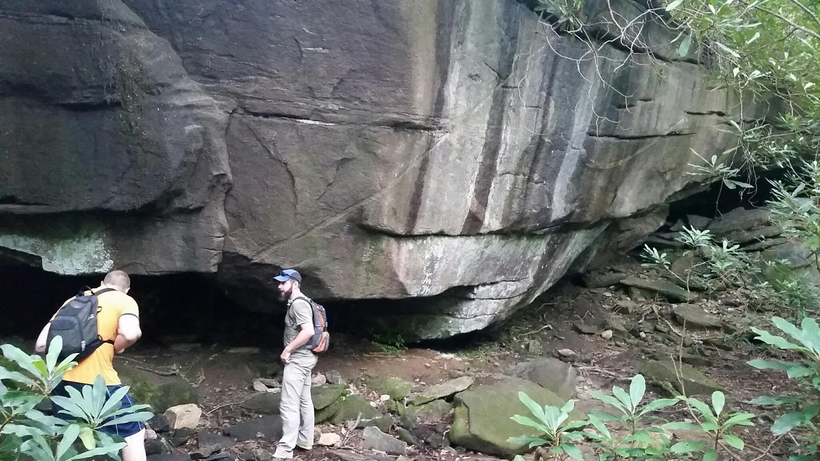
House-sized boulder in the upper sections of Windy Falls
The next stop downstream on the Horsepasture River is the Windy Falls terrace, a huge sloping rock where it would be less than easy to meet your demise. When we got there, the conditions were dry, so we were able to carefully explore around it. If that rock is wet, it is also slick, and no attempt should be made to walk on it. At the top of the area, the river rushes beneath a house sized boulder. We made no attempt to get close to the river. A slip up here, and you’re done. About halfway down the rock face is a large separation Crack that becomes a wedge after about four feet. It has been called the Crack of Doom in all seriousness and tongue-in-cheek. (Either way, it is nothing like the Crack of Doom in Linville Gorge.) We took the opportunity to make light of a serious place and play like we were falling in the Crack. 
Don’t slip on the upper terrace
The next section down came with much more difficulty. The path, which was essentially non-existent, split our group up in attempts to find the safest way down. Sheer Rock faces to the left of us, Windy Falls to the right, with the rugged tangle of North Carolina jungle filling in every space between. After using rope to scramble down dripping wet rock faces into standing puddles of black mud, we finally emerged through a pile of boulders onto the clear balcony overlooking the most powerful section of Windy Falls with the most technical section of the route still in front of us.
The Badger enters the Windy Falls keyhole
From the balcony above the plunge pool, with an overhanging cave right behind it, there are two ways down. The first and unfavorable option is over the edge. The water below obscures some hefty boulders that will win against your mass and inertia. The second option is climbing down through the rocks. The easiest way is a tight squeeze through a keyhole. That squeeze can be bypassed with the use of sturdy enough rope, and you can unsafely rappell-lite around the keyhole. Either through or around the keyhole, a rock shelf is the next stop, with the ground another 8 feet below. From here, the rocks angled down toward the water, but another passageway allowed us to travel beneath the boulder balcony into a near silent cave littered with rocks and driftwood beaten to smooth rounded edges by the Horsepasture River. A short scramble or committed walk in the water and we were at the base of the main drop. 
Kitty, Stephanie, and Luke exit the cave
Windy Falls is a raging fury of whitewater as the Horsepasture River crashes down rugged Rock to the plunge pool below. Within the walls of this gorge, the Horsepasture claims full right to its designation as a Wild and Scenic River. 
For the next several hours, the group spent their time eating lunch, taking pictures, scrambling on boulders, exploring ledges to get down river, were joined by Spencer and Stephanie, jumping off and sliding down rocks to swim in the plunge pools. The one thing I really wanted to do for myself was hang a hammock down there, and I was able to find a place after scouting a bit. One by one, the group split as we made our way from the pools, through the cave, out the keyhole, and back up through the boulders and black mud and ledges. 
Darrin goes for one of many slides on the slick rock, with Spencer on the balcony above.
Darrin, Scott, and I stopped at the same pool we visited earlier (where the Keith Green song came to mind), and we got back in the water. Scott took the water leisurely to enjoy a relaxing float about the surface. I wasn’t up to a full swim. Darrin got several more jumps and slides in. If there’s one thing to be said about hiking with Darrin, that dude loves to be in the water. Jumping off rocks into deep river plunge pools and lakes is his thing, for sure. The look on his face, man, he just loves life at that moment. Badger, Kitty, and Stephanie soon joined us, and they too happily entered the waters. It was like other lenses came over my eyes and these thoughts flooded my mind in that contemplative moment:
Team Waterfall loving Windy Falls with abandon
Loving life, there is no question. What struck me was the thought, where does that love come from? How is it that playing carefree in the waters equates with ultimate life? How is it possible that we can enjoy such a good gift as swimming in plunge pools and the sitting beneath the cooling, pummeling pressure of waterfalls? I know that we do, but what precedes that? Deeper questions than any of the pools, for sure. As I meditate on it, that train of thought ends at the Father. Man’s joy is a reflection of the Father’s joy, as we are made in His image. Raw delight points back to the Father, who is the fountain of living water Himself. All these things are gifts and yet, outside of Christ, we are not in a restored relationship with the Father and reject His goodness. We sit, like I did, on the side of the river, not wanting to commit to the waters. (I promise I did not sit out of the water to force that analogy.) In Jesus, the Father beckons us to abandon the shore and plunge into the depths of His reconciling grace to taste the satisfying pleasures of being His.
The walk back to the parking lot was uneventful. I’m surprised we made it the whole day without any timber rattler or copperhead sightings, considering where we had been poking around. For my first visit to Gorges State Park, outside of dipping into it on the Foothills Trail, I’d say it’s going to be hard to beat.
Categories
Fellowship guy friendship hiking Jones Gap Mountain Bridge Wilderness Area Rim of the Gap South Carolina The SC Project Trip report

Scrambling the Rim of the Gap

One of the definitions of the word fellowship in Merriam-Webster’s dictionary is a company of equals or friends. There are those whose fellowship is found in their draw to dive deep, wrestling to taste the air of colored forests and breathe the waters of satisfaction. Off into the Mountain Bridge Wilderness three such men went.
Erich, Jeremy, and I would begin our day together driving westward on South Carolina’s beautiful Highway 11 towards Ceasar’s Head State Park. Right before the junction with 276, we passed what is normally Lower Wildcat Falls, visible from the road. This day, it was Lower Wildcat Rock, as no water was cascading over it. I had some plans in mind to see a few South Carolina waterfalls that I hadn’t visited yet, but the water flow from Wildcat Creek wasn’t feeling too promising. Nevertheless, we pressed on, for there was more to see than waterfalls.
Very low flow at Rock Cliff Falls today
We parked just past Caesar’s Head at the parking area that also allows access for Raven Cliff Falls, though we wouldn’t be poking around there today. It’s be down the orange blaze for us – Coldspring Branch was our first trail. It was easy warmup hiking as we started out and took our turn to the Coldspring Connector towards our priority goal of the day – Rim of the Gap. First, though, we diverted to the Frank Coggins Trail and took one half of the lollipop over to Naturaland Trust Trail. We crossed 276, where Naturaland Trust goes through a landowners driveway and front yard, and less than a quarter of a mile from there came down to a cracked rock face that was normally Rock Cliff Falls. It was not dry, but it was a trickle. Beyond the Falls is an excellent rock face the we would have loved to follow further, but we had a full day ahead of us.
Talking scars on natives at the totally dry Firewater Falls
Retracing our steps back to the Frank Coggins Trail, we took the other side of the lollipop loop past Firewater Falls, which was only a dry faced overhang this day. No water whatsoever was trickling over. The conversation had turned to snakes just prior to this, and Erich was telling the story of one of the tribesman he treated in Indonesia that had a terrifyingly close encounter with an anaconda. I’ve probably heard that story over a dozen times in the six years I’ve known Erich and it never gets old.
Our next turn brought us to the Rim of the Gap Trail. Erich and I had been talking about hiking this trail for the last four years, and we’ve always diverted elsewhere. With what might be the last time we would be able to hike together for a while, we decided today would be the day. It starts out at the bridge (which was built as an Eagle Scout project by my friend Darrin’s son) over Cliff Falls, and there is a small side path where people have obviously been walking to get a view of the base of the Falls. The flow was low, but still enough to be called a waterfall. There was a sure tropical feel to that little alcove. Warning though, this was the one spot where I slipped on the slickrock. It is very slippery down there, even as low as the water volume was and without any spray from the falls. On normal flow, it would be way worse. If you do follow that worn path down, please stay off the rocks.

Cliff Falls with low flow and a tropical feel

Any fall on Rim of the Gap could be fatal. Why fatal? Well, you’re on the very edge rim of the ridge that rises to the south of Jones Gap. There is water that has to be crossed, bare rock, slick rock, roots, and shrubs that all require some technical maneuvers to pass. A casual stumble or slip could potentially have you careening off the Rim of the Gap down the mountain to be slammed into the trees and bare rock below. Is the trail dangerous? The trail is good, and fairly easy to follow. Like I said, though, it is technical. There are sections you’ll have to scramble on all fours up rock faces and navigate through boulders. Also, to watch out for is snakes. There had been a report of timber rattlesnakes spotted on Rim of the Gap the week prior on The South Carolina Project group on Facebook. OK, enough of the public service announcement.

On on of the Hamlin boy bridges above Cliff Falls
I’m happy to announce that neither myself, Jeremy, or Erich went careening off the Rim of the Gap. On the contrary, we had a great, safe time. There are awesome rock walls, flowing water cascades (which felt strange in the dryness we had already witnessed), and huge boulders to scramble through. We came upon a cave where my aforementioned friend Darrin had something growl at him from within. There is also a trip report floating around in the internet about witnessing a cougar on this trail. Whether or not there are legit cougars in the Mountain Bridge Wilderness, I don’t have much insight. I can only say that I have never seen one, but it’s fun to insert cougar lore comments into most outdoor conversations. Granted, I’ve never been stalked, either. At least… not to my knowledge.

For a good section of the trail, we could hear home construction going on in the neighborhood just at the top of the ridge, which didn’t spoil the day by any means, but did take some of the wildness out of it. Fortunately the terrain made up for a lot of that! We climbed up ledges, behind huge rock formations, behind boulders, and on trail that skirts vicariously close to the edge. We climbed beneath Weight Watchers Rock, which is a massive boulder supported by a smaller boulder and provides a just human sized gap beneath them to squeeze through. There is a walk around, which takes you closer to the edge of the gap. Hiking is slow going through the western section of the trail because even though the trail is straightforward, the terrain is not. I’ll let some of the pictures speak for themselves.
Jeremy inspecting the cougar cave. There were no cougars inside today.
Erich loving this scramble. 

The eastern section is much more mellow and easy to follow. So easy in fact that we didn’t even see a four-point buck standing at the trail right before we walked up on it. He took off like a shot back into the forest, but only far enough in for him to be disguised while he kept an eye on us. As we got closer to the Jones Gap Trail and Middle Saluda River, the ground began to have more soggy sections. Rim of the Gap ended, and we made for the river to cool off, soak our shirts and hats, snack, and refill on water. 

It really is the Rim of the Gap
Now for the climb back up to the parking lot. Fortunately, it’s a gradual climb (for the most part) over 5 miles. Jones Gap Trail has a lot of rocks on it which increase the difficulty due to trip factor, but overall it’s not that bad. It meanders fairly close to the river for much of it, which we took advantage of. At one point, visible from the trail, was a smaller waterfall on the river with a pool beneath it and dry rock on one side. The day was hot, probably over 90°F, and we’d been hiking for several hours. Sweaty and dirty, the cool water of the Middle Saluda was too tempting to resist. The waterfall had a large rock at the base of it, so sliding down it wasn’t much of an option. A few feet downstream, however, was a sandy-bottomed pool wallowed out into the bedrock. Accompanied by tiny fish, we took turns submersing ourselves beneath the water of a natural bathtub formation in the river. Life giving water, dropping heat-exhausting body temperatures, and revitalizing sore limbs. Good stuff. I had wanted to get a glimpse of Jones Gap Falls, but we completely blew past it. For another day.
The bathtub in the Middle Saluda River
We made the turn onto Coldspring Branch Trail and decided to take it to the top of the ridge instead of climbing up Bill Kimball and the face of El Lieutenant. The last time I had been on Coldspring Branch was last November on the snowy day, so it looked plenty different yet familiar on this tropical August weekend as it bubbled and rushed down the Valley to the Middle Saluda River below. Hiking out felt like a grunt especially at the end of the day, and though we had seen and hiked through a lot of incredible places, it was a welcome relaxing moment to end our 13.5 mile hike. I also need to report that we didn’t see one rattlesnake.
We had eaten lunch a few hours earlier and were ready for a little something extra, so we stopped at the F-Mart for one of “the best hot dogs in town.” Now with a little sustenance in our bellies, we stopped off the day with a trip to the Swamp Rabbit Brewery & Taproom for a glass of Red Whitey. Their Raspberry White Ale is an award winner, and it did not disappoint. 
Swamp Rabbit Brewery’s Red Whitey
It’s easy to retrace our steps here on a blog post, but our conversation is not so easy to retrace. While it feels like we were all over the map over the course of 13.5 miles, we were even more all over in our discussion. This is the bedrock of the fellowship: to know God as Father and the pleasure that results from that relationship. To dive into the depths of what it means to be reconciled to the Father through the Son who bought these brothers with His blood is an amazing thing. Out of that, should we be talking less and doing more? Perhaps not. Without understanding the ramifications of the relationship with Father, what is anything we would set our hands and feet to do? We would burn out. His love is satisfying, motivating, and sustaining, and what a good gift He has given to create fellowships of His own. Fellowships who delight in Him.