 |
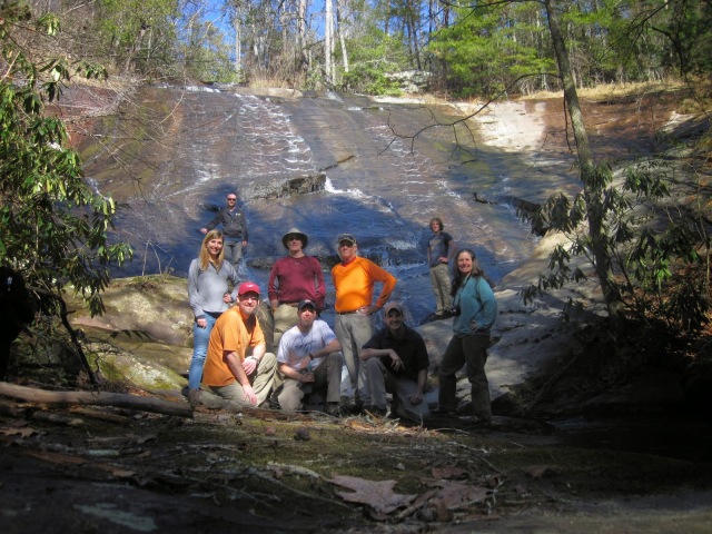
| Group shot at Lower New Millenium Falls |
This is a hike I have been wanting to do for a long time. How it came together started with me visiting Sweet Thing on Slickum a couple years ago. I was talking to my friend Jeff Raubaud about it, and he was telling me about a huge bald rock area just above it (not Bald Rock Heritage Preserve, but a nearby unnamed bald). As I read more about the area, I found there were quite a few waterfalls concentrated nearby, all of this within relatively short hiking distance from the corner of highways 11 and 276 towards Caesar’s Head. I had originally planned this hike in December of 2013, and we had to cancel because of freezing rain. I don’t hike in that. Fourteen months and several conversations and discoveries later, we made the agenda bigger and were able to see what is just off the beaten path only 30 minutes from downtown Greenville, South Carolina.
The group was built from already established hiking buddies and Facebook friends. Coming from Team Waterfall, The Tanasee Gap Group, or somewhere in between, the active participants of the hike were: Darrin Hamlin, Jack Thyen, Emily Felty, Todd Ransom, Bob Sedler, Spencer Clary, Stephanie Brooks, Johnny Corn (who wouldn’t join until later in the day), myself, and perhaps most suspicious of all… Thomas “The Honey Badger” Mabry. All of us are experienced hikers, bushwhackers, and off-trail navigators. I don’t know if you’d call it an elite group, but there was certainly nothing green about anybody. When I planned the event, everyone knew that we’d be getting wet and dirty, and they still showed up.
Before we continue, this kind of experience is bound to make someone say, “I’ve gotta go see that!” Consider this the public service announcement. Experience at waterfalls is not enough to keep you safe. Skilled hikers have taken wrong steps on rocks they didn’t realize were slick and have fallen and been killed at waterfalls. It takes nearly nothing for you or your dog to go careening off the edge. People die at waterfalls. I’m not trying to scare you, but if you’re going waterfalling (a subcategory of hiking), people die at waterfalls. For real. Waterfalls don’t care who you are. If you try to follow in the footsteps of hikers who have gone before you, realize that you are taking risks that you alone are responsible for, and that you are participating in something that is more likely to harm you than bears or snakes.
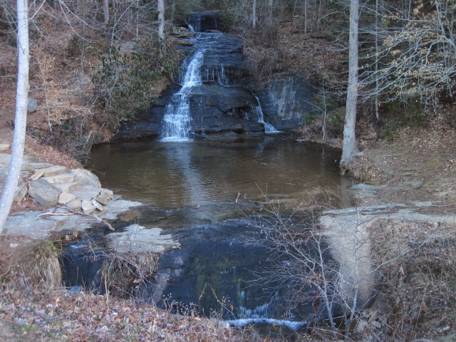 |
| Lower and Middle Wildcat Falls |
We met at
Wildcat Wayside Park on Highway 11 just outside of Cleveland, SC at 8:00AM, and my thermometer read a chilly 23°F. The first leg of our hike would be the easy 1 mile loop for Wildcat Falls. Lower Wildcat Falls is easily seen from the road, and Middle Wildcat Falls is directly visible above it, which you can access by a short series of steps. Crossing the creek, there’s a large sign which indicates where the upper falls are and another plainly marked “Falls.” Taking the right, we passed the remains of an old foundation and chimney, came to the generically named Falls, and within a short time were at Upper Wildcat Falls. There are warning signs in a few places because people have fallen to their deaths here.
Google it. There are a lot of slick rocks, which can cause you to take a nasty or fatal fall. None of us climbed to the top of the falls, but we did scramble around the base of it. We’ve been hiking for only 30 minutes and bagged four waterfalls. Not a bad way to start the day.
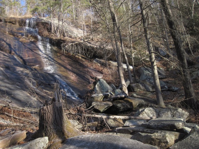 |
| Upper Wildcat Falls |
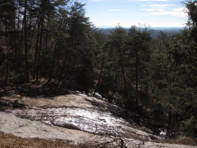
We knew there was a side trail over to a series of falls called New Millenium Falls. though it was disguised at the entrance. Probably for good reason. The side trail over to Slickum Creek was pretty easy once we were on it, and we passed under a huge rock overhang area. We stopped there, shot some group photos, and screwed around for a little bit. Hiker trash central. Spencer’s Cistern – which he didn’t name – was a good laugh, but not something I’d drop a waypoint at. That joke was for us. Sorry. As we went down the trail, which was still actual trail at this point, we started getting into the balds. This area really reminded me a lot of Little Green Mountain in Panthertown. It really is a fun area to poke around. We found some flagging and followed it to bring us right to Middle New Millenium Falls, which is a huge round boulder with the creek lazily flowing over it. It’s tough to get a good frontal view of it, as the guidebooks have said. It’s a great water source if you’re running low. Upper New Millenium Falls is not far upstream, and we had to step on some pretty soggy shoreline to hike up the creek to get a good view of it. This is all a really cool area, and we started seeing remains of old moonshine stills scattered about.
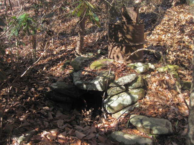 |
| The remains of a very intact moonshine still. |
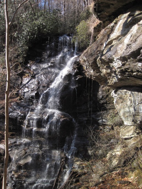
From here, we wanted to hike to Slickum Falls, which is also known as Heritage Falls. It is normally accessed from top by a trail in the Eva Russell Chandler Heritage Preserve via Persimmon Ridge Road. We were coming in from the bottom. Spencer, Stephanie and Jack had seen some flagging back on a bald before we go to Middle New Millenium, which they said brought them out near the top of Upper New Millenium. Do we go back that way, or start bushwhacking up the creek? We decided to started the ‘shwack. Following Slickum Creek when we could and moving away when it got too thick, we eventually came to the base of Slickum Falls. This is a super cool spot because it’s a cataract bog. The ground is really soggy, and lots of rare plants and flowers grow there including carnivorous plants like the pitcher plant and sundew plant. There were quite a few clusters of pitcher plants, at least what was left of last years growth, some which looked like there was still plenty of life in them. While we’re hanging out here, Darrin announces he wants to show us one of the best spots in this area, which is the top section of Slickum Falls. There’s a huge crack in the rock here that the creek pours through, with more moonshine stills at the bottom. It’s possible to follow the contour around the rock face and get to the bald at the top of the falls. We hung out here for a while, as the day was clear and we were able to make out Paris Mountain and the buildings of downtown Greenville. What a spectacular view to have! While we were there enjoying it, a couple hiked in from the road above, which is a short hike. They looked at us like they definitely didn’t expect to see nine people hanging out on the rock face. The guy asked, “Did y’all have the red RAV4 at the parking spot?” I enjoyed telling him that it was not, we had parked on Highway 11 and came in from the bottom. Why I cared that people I didn’t know were impressed with us, I don’t know. Just a consideration, if you’re reading this and coming in from the top, that Persimmon Ridge Road can be a rough one.
 |
| The view from atop Slickum/Heritage Falls |
So what now? Darrin had found a waterfall last year with some pretty unique features and named it Spider Tunnel Falls, due to almost stepping on the biggest Fisher Spider he had ever seen. Originally, we had planned to go back down Slickum Creek and follow the appropriate contour over to the waterfall. What we actually decided to do was a straight bushwhack in its general direction to rediscover it from upstream. The creek doesn’t show up on Google Maps, so we were aiming at Spider Tunnel Falls on Darrin’s memory of coming to it from a different direction. One of the cool spots we saw in this area was where a spring was bubbling straight up out of the ground. That turned into a creek that looked familiar to him, and we bushwhacked around until the creek disappeared. Dropping down the side, we slid to a lower ledge, following it around behind a large boulder to be face to face with Spider Tunnel Falls. Fortunately, we didn’t see any spiders. I have to say, this was a huge highlight to this trip. The creek comes over the edge of the rounded rock face, falls down into a slot canyon that’s 10-12′ deep, and runs out the other side. Beyond cool, unlike any waterfall I’d ever seen. While everyone was taking their pictures up top, I slid down the leaves and mud (on the side of the falls, not in the falls), and snapped a few pictures with my tripod in the water. The talk of coming back when it warms up was quick to come, but carpe diem. I took off my boots and socks, rolled up my pant legs, and waded into the slot canyon. Seriously, South Carolina? You rock my socks off. *ba dum!* I’m not giving up the location on this one, but I’m sure someone who has visited it before would love to go back and see it again. That might be something to inquire about.
 |
| Poking around Spider Tunnel Falls |
More bushwhacking! That’s what we’d be up to next as we worked our way back to Slickum Creek. It got kinda thick in there. We were aiming for Lower New Millenium Falls, as we had only seen the upper and middle sections of it. I had the way points of all the places we’d visited so far, so we could see where we needed to go, but we weren’t sure exactly how far downstream the Lower Falls was from the Middle Falls. We aimed, stayed on contour, fought some of thick rhododendron that the Carolina’s are known for, and happened to emerge at the most perfect place to cross the creek, which was just below Lower New Millenium Falls. I wish I could say that we planned it as well as it turned out! The Lower Falls are really cool, with some large boulders, trees to climb to get a better view, and even a couple large potholes in the side of the rocks (which were pretty sketchy looking to try and climb in and out of). This is where we took our group shot that’s at the beginning of this post.
We followed Slickum Creek downstream, criss-crossing over it, coming towards one of my favorite falls of all time. Darrin and I were separated from the group, as we took an opposite side of the creek for our approach. There was the drop off, and we were standing on top of of Sweet Thing on Slickum. There’s no easy way to get down from the top, or get up from the bottom. On the side we came down, we had to scramble down rock shelves that still had icicles clinging to them. Even though it had warmed up to a nice 60°F, this pocket is still deep in the shadows. On the opposite side, there is steep round-about sidehilling to climb down, and then another creek crossing. Sweet Thing is a 20′ waterfall that pours into a grotto with a beautiful pool at the base that’s perfect for wading. It’s always a favorite, and I love taking people there because no one ever suspects this beauty is nearby. It’s easy to linger at. We met up with our friend Johnny Corn here, and he joined us for the rest of our day.
 |
| Sweet Thing on Slickum |
A few more minutes downstream and we were at Last Cascade of Slickum Creek. I took one shot, thinking it was an unnamed waterfall and that Last Cascade was in reality located on the south side of Highway 11. I was wrong. There’s no waterfalls south of highway 11, but where Slickum Creek enters the Middle Saluda River is a very pleasant and scenic spot. There’s some thick briers in there, though. As we emerged back out on Highway 11, Todd and I spotted the first Trout Lily of the day. This was a new flower for me, but they are apparently one of the first signs that Spring is jst around the corner.
We walked back to the cars at Wildcat, where we had lunch. From there, we all piled into two vehicles and drove up 276 towards Caesar’s Head. Pulling off on the side of the road, we picked up the Pinnacle Pass Trail in the Mountain Bridge Wilderness Area. We hiked in along typical scenery of the area, until we veered off the trail at some point. The rolling mountainsides and bubbling brooks eventually gave way to rugged terrain of exposed rock and boulder choked waterways. There’s no trail down there, so it’s really just finding the path of least resistance. Fortunately, it’s clear enough to not exactly be a bushwhack, so it’s pretty much just off-trail navigating and boulder scrambling. We passed by a lower waterfall that as far as we know has been unnamed, so Darrin references it as Evan’s Falls. Through the trees, I could start to make out Mashbox Falls. Once we got to the base of it, Darrin’s comments rang true, “It’s one of the most underrated waterfalls in the Mountain Bridge Wilderness Area.” Indeed! Water plunging eighty feet down over rugged shelves, with a steep hill to one side that brings you beneath a large rock overhang to what’s been referred to as the Photographer’s Perch. Getting up there will get your heart pumping.
 |
| Mashbox Falls as seen from The Photographer’s Perch |
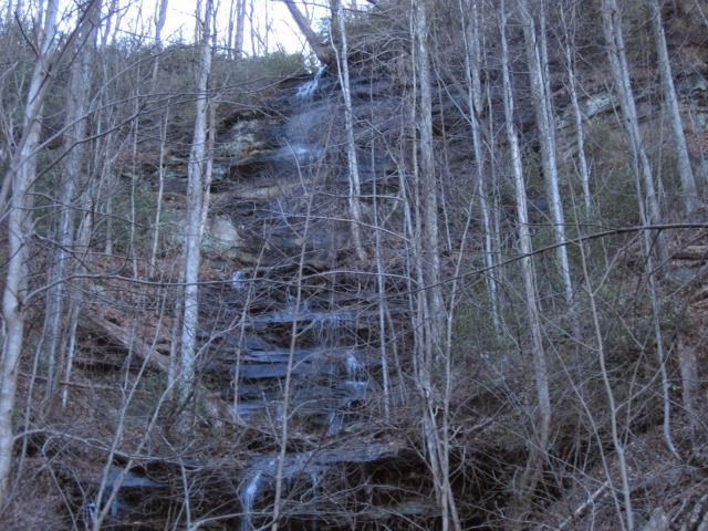
Leaving Mashbox Falls, we followed the creek back down and came to another tributary which we followed up to Misty Falls. It’s not a high flow falls. In fact, it was fairly misty, so I suppose the name is fitting. Fortunately, we were visiting in the winter when all the leaves were down so we had an excellent view of the falls. In the spring or summer, the falls would be obscured. Spencer had scrambled up Misty Falls about halfway, and when he got back (which took him a few minutes), he reported that he heard cars right above him. That confirmed what we were looking at on the GPS, that the road was only .13 miles away. People drive right past all this excellence and have no idea that it’s so close!
Decision time. Option A is that we retraced our steps back to the Pinnacle Pass Trail for our exit. This would be less work, but more distance and time. Option B was to climb straight up the ridge towards the road. We took a vote, and the majority raised their hands for Option B. The rough climb out, straight up a mud cliff. I made several attempts to get traction to get up, and many of those failed. I would dig my boot in, only for the earth to give way and I’d slide back down. Using downed trees, rotten logs, and whatever else we could hold onto, all ten of us slowly made our way up the ridge back to a logging road that led us to the Pinnacle Pass Trail. Looking at the photo of Misty Falls below, the hill was basically the same kind of steepness. Up until this point, the hike had been relatively easy, aside from a few cuts and scrapes from briers and untangling ourselves from rhododendron thickets. Getting up that ridge felt like it took more concentrated effort than anything else we had done the rest of the day. Navigating through the woods took the mental effort, but climbing out called on every reserve of strength, energy, and stamina we had left. Thomas gave it the official stamp of a
Certified Honey Badger Hike. We quickly made it back to the vehicles, and then back down the mountain. We found a small pull off out of the way to enjoy a short group celebration of the day in the spirit of the day.
 |
| Misty Falls |
What a great day we had exploring! To be honest, when I organized this event, I wasn’t expecting it to turn out as profitable as it was. We visited 14 waterfalls and countless other cascades. The views from the balds were amazing. Getting barefoot and rolling up my pant legs to climb into the slot canyon of Spider Tunnel Falls in the freezing water was exhilarating. The company we kept was top notch. For all the places we went, for all the pants that were torn, for all the dirty hands and scraped arms, everyone was having a great time. Thanks again everyone for such a great day in the woods and waterways. Well, except for the 11th guy… what WAS his name?!?


