
It seemed like a perfect way to start the day, but I didn’t realize it would be so fitting for the days events. Awake early for a hike into Panthertown Valley, I was on my way to pick up my friend Ben, who I haven’t seen since our January 2013 hike in Linville Gorge. This would be his first time hiking in Panthertown. Over the car stereo, Andrew Peterson ushered in the day.
Sarah, take me by my arm
Tomorrow we are Canaan bound
Tomorrow we are Canaan bound
Where westward sails the golden sun
And Hebron’s hills are amber crowned
Ben and I got to Cold Mountain Rd about half an hour before our rendezvous time with the rest of the group, so we do what I always do if I’m running early for a group hike on this side of the valley: we stopped at telephone pole 61 and hiked down to Raven Rock Falls. It never disappoints. It’s a short walk, with some soggy and slick parts, to a very lovely waterfall. We headed back to the car, took the left turn at Canaan Land, and still made it to Cold Mountain parking on time.

Ben and I met up with Todd Ransom and Thomas Mabry, who I’m friends with through the Exploring Panthertown Valley group. We had big plans for the day of waterfalls, rivers, bushwhacks, footpaths, and clifftop views, but we didn’t even consult the map at the trailhead. We had planned it, even though we would have to hike a couple miles to our first waypoint. Red Butt Falls would be the first dot to connect.
We made it up Devil’s Elbow and down the footpath to Red Butt Falls in good time. The Tuckaseegee River was flowing lower today. We stopped on the dry rock to get prepped for entering the river, and had our minds on our highlighted waypoint of Lichen Falls.
In my efforts to carry less, this would be the first trip I used a LifeStraw on. Kneeling at Red Butt Falls, I had my first deep drink straight from the Tuckaseegee River. It was the first of several uses of the LifeStraw throughout the day, and I’m happy to report post-hike that I never had any ill effects.
We crossed the falls without any slips to create our own red butts, passed Coffee Rock, and entered the Tuck. Deciding where to enter is one of the trickier aspects of hiking downstream. If you stay on the banks to the far left, which is where you’ll naturally stay after crossing over Red Butt Falls, you’ll be really prone to slipping on the slick rock. Once passing Coffee Rock, there are boulders in the river you can get to, and you’ll be in up to your calves at this point unless you’re rock hopping. You will get wet from here.
The last time I was here during the 20 waterfalls last April, and the water level was significantly lower this time. The temperature was significantly higher, as well. Both of those elements made it a much easier trip. Less obstacles, and less stinging cold. It’s a lot easier to navigate terrain when your feet aren’t in pain.
This was my first river hike wearing a pair of Keen Newport H2 sandals, which I actually wore the whole day. They provided excellent traction on the wet river rocks, even with the current. I love walking in this river, and it really just makes me want to explore Panthertown via its waterways than its trail system. In surprisingly short time, so much so that I didn’t even realize we had passed by Honeycamp Branch, we were at the giant boulders that tell you to “Look up, you’re at Lichen Falls.” This is one of my favorite places in Panthertown. It’s like a jewel in the crown of the river gorge.


After several pictures, we crawled down the boulders and crawled on hands and knees through rhododendron along the bank of the Tuck. From here, we explored downstream a little ways. After an extremely shallow section, the whole area became bathed in green. Everywhere we looked, it was as if we were soaking in our surroundings through green lenses. Every rock was lush with different kind of mosses. Sunlight broke through the canopy at what seemed to be the perfect angles to refract green luminescent light against every surface.


We had received some intel on an old Carlton McNeill trail in the area, so we opted to take that up to the peak of Devil’s Elbow. It was roughly 300′ in elevation from where we were at, to which Todd quipped, “Don’t worry, it’s all at once!” It was definitely the steepest terrain we had been on up to that point. As it turns out, there was not much of a trail there at all. More like the path of least resistance through a rhododendron thicket. I do have to applaud Todd’s navigational skills here, as we came out in the dead corner of the trail on Devil’s Elbow. So we will just call it perfect aim.
After a couple misdirections and standing on ant hills, we made our way along the unofficial footpath up Shelton Pisgah mountain. There is a pretty good overlook there. Comparing the GPS track to Burt Kornegay’s map got me mixed up. We followed the path easily, and it only matches the track on the Kornegay map roughly. If you’re counting corners and turns and comparing it, it’s not exact. Anyway, Cold Mountain is big and bold right in your face as the trail skirts the cliff for a few yards.


We were running low on water and this point, and the closest source was at Little Green Creek. Like a drop of providence, we came upon a new (looking at least!) Nalgene bottle full of water. Not quite trustworthy enough to drink straight out of, but fortunately Thomas had brought along his new LifeStraw, as well. Certainly good enough for a LifeStraw. We finally made it to Little Green Creek and had a proper resupply of water. Even at a shallow low flow, this was a good source with clear crisp mountain creek water.
Looking at the GPS, High Bethel on Cold Mountain was only two-tenths of a mile away, as the crow flies. Turns out one (like myself) should save such group announcements until confirming with the trail map. The distance between our position and High Bethel as the crow flies was quite different from the distance between our position and High Bethel along the actual trail. Fortunately, my error gave the guys an opportunity for a bit of fun with me. The effort from the grunt of a climb up (the trail) to High Bethel was quickly forgotten as we emerged out of the green rhododendron tunnel to be bathed in sunlight and take in the stunning views of Panthertown and beyond. Northwards, I was able to make out five ridgelines beyond Panthertown, with atmospheric perspective giving each ridge its own distinct azure hue.


The distinct feature of High Bethel is the altar that was constructed by Canaan Land below. No sacrifice is needed on the altar, but it did make a good spot to spread the map out and compare to our surroundings to the paper in front of us. It was certainly a different perspective than seeing the valley from the Overlook Trail, Salt Rock, or Little Green Mountain.
It certainly took far less time and effort to get down from High Bethel than it took to climb up it. We were back at Little Green Creek in no time. Thomas and I took a few long swigs from our (induvidual) LifeStraws and headed down the path back to Devil’s Elbow. Somewhere along the line, our conversation turned to politics. Never any heat in the discussion because we all just seemed to agree that it was all broken. I was reminded of a comment my friend Matt Rawlings had made recently, “Everything has been broken since Genesis 3.” Humorous, but there is much truth in it as well.
We emerged onto Devil’s Elbow Trail and took it directly across the Panthertown Valley Trail to a footpath that took us to Schoolhouse Falls. I much preferred this route. For Ben’s first visit, we couldn’t not go to Schoolhouse Falls. On a downside, we must have disturbed a yellow jacket next, because one buzzed Ben a couple times. This path brings you to the route that goes behind Schoolhouse Falls. We had been in solitude the entire day, enjoying the green shades of the river and twilight beneath the canopy. Now we were met with several groups who came to experience Panthertown, all concentrated in its most iconic waterfall.


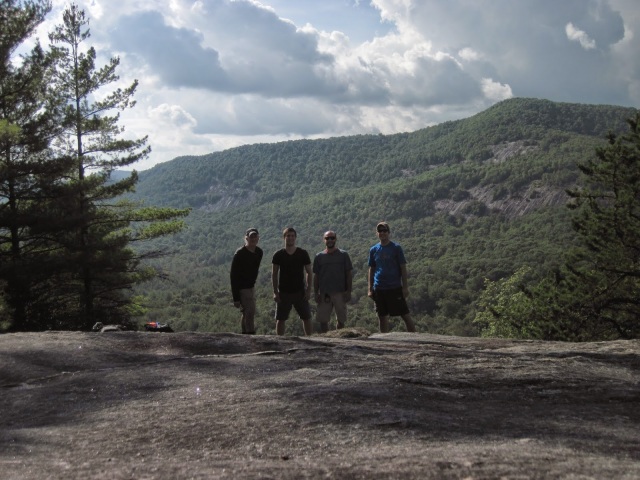
One final destination. One final overlook. One final climb up a mountain. We were at the base of Little Green Mountain already, and Tranquility Point from the peak is one of the best highlights of Panthertown Valley. We were a lot slower climbing Little Green. Our food supplies had been consumed, and talk of cheeseburgers began to dominate our conversations. One footfall after another, stride not quite so long, we emerged from another canopy onto the granite bald. A wonderful and rewarding view to close our day!

The final destination would be Cold Mountain Parking. More slow pace, but we weren’t in a rush, either. No more conquering or exploring to be done. No more studying maps or decisions to be made. We bypassed the switchbacks, as we always do, and heard the music coming from the speakers at the gate to Canaan Land. It was absent on our way in, but that sound is always the sound of “just a few more steps!” When we got back to the car we were tired, but not exhausted.
Canaan bound. As the music ushered back to the cars where we would find rest, I find myself very often longing for Heaven, which Canaan is a foreshadow of, in the same way. On that day with Jesus, there will be ultimate and final rest, where the one who carved these mountains and rivers will make right everything that is broken, and reverse the effects of Genesis 3 once and for all.
