 |
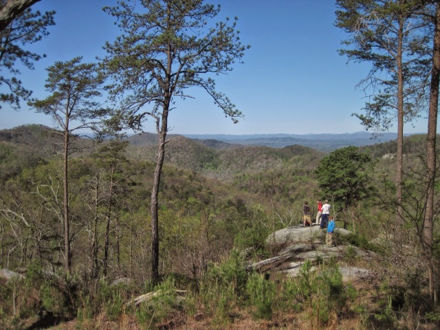
| The group stopping at an overlook on the way to the summit of Big Rock Mountain. |
Big Rock Mountain has been showing up a lot lately in the photo feeds of my fellow explorer friends. After seeing a few of those photos, I knew I had to get on that mountain and see what was going on up there. Surely there couldn’t be a place like this in South Carolina. Lew me tell you, Big Rock is a scramblers paradise. I’m not much involved in any kind of rock climbing or bouldering any more, and I haven’t made any effort to begin rappelling. Scrambling and bushwhacking though, that’s what we found just outside of Pickens, SC.
The crew today would be myself, Steve (twice veteran of Linville Gorge), Josh (once veteran of Linville Gorge), Wally (who I hiked with at Mountain Bridge Wilderness and El Lieutenant in the snow), and new hiking buddies Stan and Jonathan. After snagging my typical prehike breakfast at Dunkin Donuts in Traveler’s Rest (bacon egg and cheese on a Manager’s Special cheese covered bagel… oh yeah), I made the drive like I was heading to Panthertown, but I would be at my destination much sooner. A 45 minute drive from Traveler’s Rest brought us to the obscure parking lot for Nine Times, where we could access either the Preserve or the Forest. Yeah, it’s split up. We would go beyond the red gate, then the gate warning us that security cameras were in use, so we could explore Big Rock Mountain.
Before coming, I had very little information to go on. That’s my excuse, at least, except it’s not much of one. I had just bought the Nine Times & Big Rock Outdoor Companion (authored by local resident, Brad Caldwell) earlier in the week, but to be honest I didn’t thoroughly read it. I knew roundabout where we would be going, and assumed there was a pretty clear path up to the top. After all, I could make out the road from the satellite imagery. Should be no problem, right? Well, with my decision making skills in a bit of a fuzz this morning, we cut across a logged area and into the woods beyond instead of just following the road. On the positive side, we got to the ridge of the mountain in only half a mile instead of one-and-a-quarter-mile. On the negative side, it was a steepish bushwhack. I mean, I’ve hiked up worse and made worse errors, but this took us on the route to expend a ton of our energy reserves at the beginning of the hike, Awesome!
 |
| Pink Mountain in the foreground. What is the rocky mountain behind the furthest ridges? |
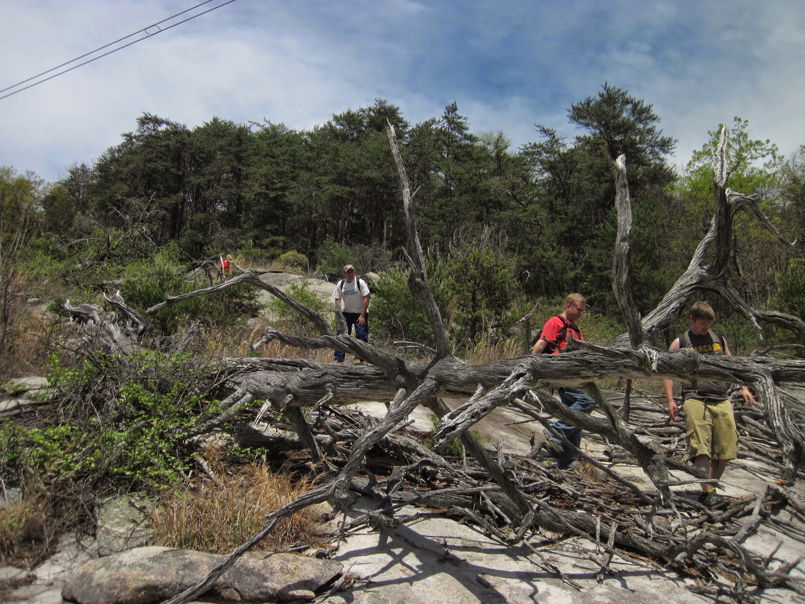
We followed some old semblance of trail (or overgrown logging road, possibly) right on the spine of the ridge over to the summit of Big Rock. We could see where we were going so our direction was good. I mean, there’s a mountain with a huge rock pile on it. It’s kinda hard to miss. Finally, some of those big rocks started to emerge. “Whoa, check that out!” That’s what started to erupt from this group of hikers. A few really large boulders were on the path (ha, path, if you can call it that) we were on. At first, we were only seeing them, then hiking around them, and then pressed into them as the briers, downfall, and bushes proved the exposed rock to be the path of least resistance. It was at this point that we lost Wally to his wonder and he scrambled up those big rocks on Big Rock, leaving us to follow him up. Even the house sized boulder that he managed to get to the top of was not the peak, but once we were all up there the view was incredible. There was a large flatish mountain we first thought was Table Rock, but I quickly realized that it was in the wrong direction. I’m still working on figuring that out, so if anyone has any help with that, I’d love for you to say so in the comments here. Looking at the maps, I am thinking that it was Whiteside Mountain, but I could be wrong. A bit further up and the summit of Big Rock Mountain has a big flat rock on it, almost like some kind of altar. Stan and I chilled out up here, as he jokes that one of his biggest problems in life was a farmer’s tan. Through the trees, we were able to easily make out Table Rock, The Stool, and Cesaer’s Head beyond. Based on GPS distances readings, we were 8 miles away. Once we were all at the top, and Wally is like, “On to Pink Mountain!” which is the closest mountain to the northwest, within the forest. He didn’t realize what I had planned for the day. I think a few of the guys didn’t realize what I had planned for the day, including me. This is where the fun would begin.
 |
| Table Rock, The Stool, and Cesaer’s Head from the Big Rock summit |
I’m not really sure why I planned this the way I did. Oh yeah, it’s 1.75 miles to the top, we’ll walk around a little bit, and then come back down. Easy! Well, that didn’t include the unplanned direct brute force route to the top of the mountain. I knew I wanted to climb around on some Big Rocks, but I guess the deceptiveness of Google Earth combined with the photos that were of nearly all rock, I wasn’t thinking about all the waist high scrub and briers we would have to bushwhack through to access many of the areas. Sorry Stan, I told you shorts would be fine. Look at it this way, now you have lots of cool hiking scars on your legs. I saw some of the meanest looking briers I have ever seen up on that mountain. It is a vicious place! As I watched all the guys navigate through the scrub, I could tell the difference that Linville Gorge had made on Steve. He just seemed to spot things in a subtle different way. Climbing up on one of the boulders, Wally and I made a rough determination of where we wanted to go and how we would get there. Going by the guidebook, one area I wanted to be was at the Shaman’s Cave Boulder. We spotted it from a higher vantage point, but our route would have to take us back towards the summit as we worked around some of the more sheer rock faces.
 |
| The guys climbing up one of the many cracks in the boulder maze. |
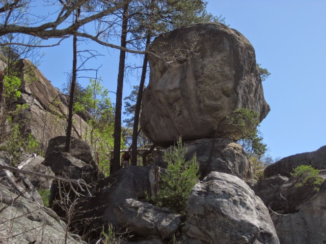
On our way down, we passed through the Big Slopey Project/The Cravasse Boulder. Way cool! This crack was one of my favorite places that we went through on the mountain. I got to do a few chimneying moves in there. Really, just to move my body in ways like that feels great. I love that feeling of just climbing on stuff, We worked down cracks, around boulders, through bushes, up gullies, and finally found ourselves at the Shaman’s Cave Boulder. We found an old ragged hammock that looks like it gave way a while ago. For the adventurous, it’d be a great campsite. There is a fire ring, and a couple bolts in the rocks for hanging a hammock that is not so ragged and still in working condition. Wally is a guy that loves to move and be active. That much is obvious. He asked me what was beyond my comfort level, so I told him anything that I would have to explain to his wife. I knew what he was thinking. Straight up the tree to the top of the Shaman’s Cave Boulder he went. How’s the view up there?? He replies, “Pretty much the same.” Coming down was a bit slower and meticulous. Fortunately, I won’t have to explain anything to his wife. Nicely done, buddy.
 |
| Shaman’s Cave Boulder |
We were looking back directly at the Main Wall, and the guide had some hints towards a cave area. Naturally, I would want to find that. What is the fascination with caves? Sure, there is that sense to say, “I really want to stand on that big rock” but to enter into the earth? I’m not sure what the draw is, but for some, the allure of a cave is difficult to resist. Well, I just gave into it. Making sure everyone in the group was still doing OK, we pressed on along the Main Wall. I didn’t want to descend too low as to miss the cave for the sake of an easier route, so I stayed a bit higher. Maybe not such a great idea as far as getting snagged on briers goes. Really, I could have avoided it. We came to the base of a huge rock, and the group split ways. A few went left, a few went right. After a few moments of indecision, I called out to the left group and asked what it looked like over there. “I don’t know, awesome!” Turns out it was awesome because the cave area was there. Really, it’s a chimney, but really, it was what I was looking for! You can climb in and over a rock at one end of the crack and come out into the main area of the cave. Really cool, but not for everyone, for sure.
 |
| Wally and Stan still at our lunch spot |
Wally, Stan and I climbed up on the top of a flat rock for our lunch break, and Josh, Jonathan and Steve hung out just below the climb. I scarfed my typical hikertrash lunch of a sandwich with peanut butter, bananas, and craisins, then scrambled over towards the next set of ledges and boulders. Looking back and seeing the cliff that we had eaten lunch on top of, I just had a good laugh of enjoyment at seeing where we had been sitting. After poking around the Flowering Hominid area, we decided it was time to start working back towards the car. Looking at my GPS, we were directly below the summit of the mountain we had stood on earlier. Three options: (1) we could hike down the mountain into someone’s yard, which I was not about to do. (2) hike back through the maze of boulders, which would be the long ways (3) the direct route – UP. Either we could go up right in front of us, or bushwhack further east and take a slab up there. Wally and Stan decided to scout out what was right in front of us. They called down that it was actionable, though not in those words. Based on the guide book, I think we went up the Joe Dirt route, which was rated as a 5.2 pitch.
 |
| Before we climbed back up to the summit |
Though it was a bit steep and sketchy in parts, we made it back to the summit. Somehow, we got separated coming down towards the ridgeline, but we were able to reconvene with a bit of effort. On the way out, I definitely did not want to come back down the way we had come up, but rather find the “right” way. Looking at my GPS, Stan came alongside with his cellphone and pulled up the satellite imagery of where we were. I could see the road on the satellite, and we were way off it. I guess that’s too much time trying to figure out where the rocks I wanted to visit and not enough looking at the route up the mountain. Sadly, it was really obvious. It’s a dirt road. We came down the rocky cliff faces beneath the power lines, which was a challenge in itself. The briers got really thick in there, and it was like hiking through velcro because the thorns would grab and not let you go any further until you pulled yourself free. I felt sorry again for Stan and his shorts. Sorry buddy. Anyone who knows anything about Nine Times has to be rolling their eyes at me as they read this. Go ahead, I deserve it. I poorly planned getting up the mountain. Next time will be better.
 |
| Coming down the mountain in one of the cleanest and easiest to hike stretches |
We made it back to the cars fine enough, after some more bushes, briers, and slides to access the dirt road. As we were putting our gear in the trunks, Brad Caldwell pulled up. It was great to meet him and share a few short anecdotes about our time on the mountain. He said that normally, we would be guaranteed to see rattlesnakes in the area. I was surprised we didn’t see any snakes, to be honest. We did see a few yellow jackets, but I didn’t ever disturb any nests where we got swarmed. The Lord blessed us with a safe, active, and wondrous day on the mountain. Really, a great notch in The South Carolina Project for me. Tracked distance on the GPS shows us at 4.25miles. We climbed 1206ft in elevation, and descended 1145ft (How does that work?). The highest elevation we were at was 1803ft.
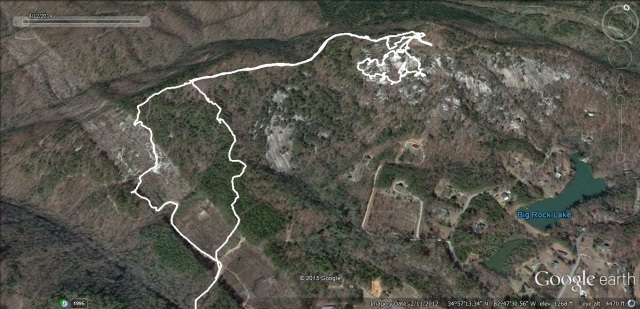 |
| GPS track overlay onto Google Earth of our hike |
I do want to say a few things about the area, though, for anyone considering an adventure there. Yes, it’s incredible, I’d never seen anything like it in South Carolina, and the boulder maze was incredible to navigate. I had a blast! Navigating that boulderfield is not easy hiking, though. There is a lot of route finding, trying to work the puzzle of which is the best way, the least resistant way. There are a lot of scratchy bushes that will not ultimately hurt you but will draw blood, The kind of adventure you’ll find on Big Rock is not for everyone, but for those who love that kind of thing, it holds mega rewards. Biggest downsides: the boulderfields are south facing, so you get the full brunt of the sun. Summertime hiking would be miserable due to the heat reflecting off those rocks. Combine that with the lack of any water, creeks or streams on the mountain, and you’ve got yourself a challenge. Really, just know what you’re getting into and prepare well by packing enough water and researching your route (I could take my own lesson!). I know for sure that I’ll be back to explore Nine Times more thoroughly! It is an amazing and incredible area, a real hidden jewel for the state of South Carolina.